
Deliverables - Individual Media Items
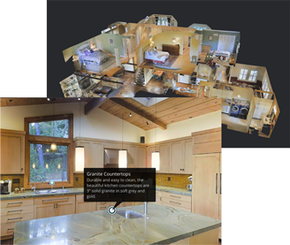
Matterport Virtual Tour
A high-resolution (HDR) virtual 3D space is created allowing users to virtually move through the scanned space using a smartphone, tablet, computer or device connected to the internet. The user is shown a three dimensional dollhouse where their virtual journey begins.
With the addition of a basic VR (Virtual Reality) Headset, users can also move through the space in 3D. VR Headsets are inexpensive ($30-$50) and may be purchased at any electronics or department stores. Users have the option of viewing the property with or without a VR headset.
A Matterport virtual space is hosted on Matterport's cloud server. We provide access to the 3D space in two formats:
1) a clickable hyperlink for MLS/Realtor.ca listings, web pages and social media posts and,
2) iFrame script (a few lines of code) which may be added to your listing's web page. This code makes a small image of the space appear with a superimposed play button.

HDR Photographs
Print quality, HDR (High Dynamic Range) photos are shot separately using a professional Canon® A-series camera and lenses, processed and optimized in Adobe® Lightroom, and delivered to you in jpg format.
These photographs are taken after the Matterport scan is completed, utilizing the photographic techniques and guidelines used by major sites like airbnb.com (specific F-Stop, ISO, shooting height, etc)
These high-quality photos may be embedded in real estate listings, websites, Google Street View for Business listings, social media or printed material.
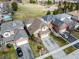
Drone Photography and Videography
We use DJI Mavic aerial drones to capture photographs and video from above.

360 Degree Photographs
360 degree, HDR (High Dynamic Range) photos are extracted from the Matterport scan and provided to you in jpg format. These photos may be used in real estate listings, websites, Google Street View for Business listings, social media or printed material.

Schematic Floor Plans
Professional Schematic Floor Plans are built from the 3 dimensional data captured by a Matterport scan, and laser scanning of additional areas by the photographer, and are highly accurate.
Floor Plans contain room labels, internal square footage calculations for each room, as well as total square footage calculations per floor, and overall. Total square footage calculations follow specific Canadian Real Estate Industry rules.
Floor Plan files are provided within 1-2 business days, in png and pdf formats, and may be used in real estate listings, websites, social media or printed material.
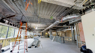
Point Cloud Data for Construction
Faster and more complete than 3D laser scanning, the Matterport Pro2 3D Camera captures 2D photography and 3D data from job sites, and automatically stitches them into a complete, immersive 3D model of a real-world job site.
A Matterport 3D model can export the point cloud to a file compatible with Autodesk ReCap® or Revit® with dimensional accuracy within 1%.
Deliverables - Services
Google Street View For Businesses
Raise your business's SEO Ranking! Matterport announced its integration with Google Street View at Google's Street View Summit in 2017. This partnership allows one-click publication of Matterport immersive 3D Spaces into Google Street View and, by extension, Google Search and Google Maps, too. This is an important development for businesses looking to enhance their Search Engine Optimization and draw in more customers.
We will perform a Matterport scan of the interior of your business and handle the upload to Google Street View.